


Kodagu, the second smallest district in Karnataka is one of the densely forested districts in the country. Of the 4106 square kilometers of Kodagu 80% of the area is covered by trees. With diverse ecosystems and associated species Kodagu is part of Western Ghats, one of the 34 hotspots of biodiversity in the world today (Mittermeier et al., 2004).
The district is known for Cauvery, Coffee, Orange, Honey, and its people. It is the home of martial men including two former commanders in chief of the Indian Military forces and an innumerable number of soldiers. The population is a mixture of native and migrant communities of the agriculturist and dependent workforce. With an economy dependent on plantation crops, forest products, and agricultural crops, the Human Development Index of Kodagu is very high and could be one of the highest for the country.
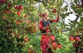
The district is the largest Coffee producer in the country and contributes to the valuable foreign exchange. Other plantation crops such as pepper, cardamom, ginger, and fruits like Coorg Mandarin, Banana are part of the coffee agroforests. The valleys are very fertile and are used for the cultivation of paddy.
Kodagu (formerly Coorg) district, extends between 11o56’ - 12o52’ N and 75o22’-76o11’E. Kodagu altitude varies between 757 m and 1727 m with the highest peak being Thadinamol Betta with an altitude of 1734 m. The climate of Kodagu is generally humid with heavy rainfall on the hills and thus a cool, equable, and pleasant climate practically all the year. The district has a steep west to the east climatic gradient. The rainfall decreases from west to east. The decrease in rainfall is accompanied by a longer dry season.
The second climatic gradient is the lengthening of the dry season from south to north and is related to seasonal advance and withdrawal of the monsoon, giving rise to variations in the floristic composition of forests with latitude. Of the 14 places with the heaviest rainfall in India four are in Karnataka and of these three are in Kodagu. They are Bhagamandala (6,032 mm), Pullingoth (5.941 mm), and Makutta (5,504 mm). The rainfall in Kodagu is dependent on the local micro-climate, resultant of the dominant vegetation (Pascal, 1988). The third factor is the temperature gradient that determines the changes in vegetation in the function of altitude and exposure. The temperature in the district varies according to the altitude of the place.
Eastern Kodagu situated partially in the plateau region experiences average temperatures as high as around 34o C during summer, while the uplands exhibit moderate temperatures ranging between 17o C and 25o C during the same period (Elouard 2000).
The vegetation in the district is the result of diverse climatic conditions and all the major tropical forest types of India are seen in the district. The forests are of evergreen nature in the western parts and are of deciduous types in the east. The diversity of habitats has contributed for a diverse flora and fauna. Kodagu has 1350 species of flowering plants which constitutes eight percent of India’s and thirty-five percent of the state’s flora (Keshavmurthy and Yoganarasimhan, 1990). The bird diversity is also very rich with over 350 species of birds (Narasimhan, 2004).
The district has one of the largest populations of Asian elephants and a very good number of Indian tigers. The diverse ecosystems also contain a wide variety of reptiles, amphibians, fish, and insects. Hence Kodagu is a treasure house of biodiversity. The district is not only an area of rich biodiversity but the native communities have been traditionally managing the natural resources in a sustainable manner. They are nature worshipers and the unique land tenure systems and tree management rules have contributed to making Kodagu a green landscape. With 1214 Devarakadus (sacred forests) spread over the landscape and with four large protected areas, the district is an ideal region to study the relevance of several small (1214) or few large (4) conservation sites for the conservation of biodiversity.
The Kodavas with other ethnic groups make up the rich tapestry of Kodagu society. Kodavas are primarily an agrarian society, cultivating paddy. Later, many of them adapted to plantation crops such as Coffee, Cardamom, Pepper, and Oranges. Betta Kuruba, Jenu Kuruba, Yerava, and Kudiya are the major tribes belonging to Kodagu.
-
i)Betta Kuruba: They were originally a nomadic group practicing Kumri (shifting or slash cultivation) but in recent years have taken up employment in the plantations and many have been rehabilitated in special colonies built for them. Apart from being good hunters, they can identify the movement of almost all the animals from their pugmarks. They use a cane, to make baskets, mats, etc used in paddy cultivation.
-
ii) Jenu Kuruba: Jenu in Kannada means “Honey” and their profession is to collect Honey from hives in forests. Their houses are lengthy structures built on poles, and bamboos find use as rafters for the roofs. Forest produces such as tubers, roots and edible greens also provide them with means of sustenance.
iii) Yerava: They are divided into four sects--Paniya Yerava, Panjiri Yerava, Badaga Yerava and Kaage Yerava.
-
iv) Kudiya: There are two sects of the Kudiyas-- the Pane Kudiya and the Theme Kudiya. The main occupation of Pane Kudiya was to collect toddy from the Baine tree (Indian Sago Palm) while the Theme Kudiyas used to collect honey from the forests. Weaving mats and baskets out of cane is also an occupation of these people.
The people of Kodagu enjoy different festivals and are related to agriculture. The first ethnic festival that comes in the year is “Kailpod”. In this festival, they worship guns, swords, and agricultural implements. This festival falls either on September second or third when the fury of the monsoon is on the decline and signifies the end of a season of paddy transplantation. It is a festival celebrated with family, friends, neighbors, and workforce with a lunch having Kadumbutt (steamed rice balls) and Pork curry as the main course. After the feast, the whole village assembles to celebrate in the village meadow (Mand – one of the protected forests) in the ceremonial dress.
Cauvery Shanakaramana is observed on 17th or 18th October, and it is believed that on this day Goddess Cauvery emerges in the form of a spring in the Kundike (tank) at Talacauvery. The thirtha (holy water) is used for all auspicious occasions. There are two activities associated with Cauvery Shankaramana. First is the erection of Bottu. Bottus are posts made from Ponga tree (pongamia pinnata). The posts are split at the top and Kaibili creepers (knetum ula) are fixed on to them. Bottus are placed in the paddy fields and other places. It would act as a resting place for the birds that would eat the insect pests of paddy, especially during the ripening stage. The second is the Kanipooje (worship of Goddess Cauvery) at home.
The next important festival is the Puthari, or the harvest festival that occurs during the last week of November or early December. This festival is generally celebrated in the “Ainmane or the ancestral house”. It is a family celebration with everyone going to the Paddy field with the traditional lamp being carried by the lady of the house. The cut sheaves of paddy are brought home and placed in front of the Thook Bolcha (lamp). The eldest of the family invokes the blessings of the ancestor and food cooked on the day is offered to the ancestors and the offering is called the “Meedi”. A week following Puthari, the whole village celebrates with folk dances at the Mand (meadow – the protected forest). Various dances called the Kolaat, Pareya Kali (war dance) are performed during the celebration.

Apart from these festivals that are special to Kodagu, each village celebrates its own village temple festivals with lots of deities. The devakad or the sacred forests is an important institution of social relevance in Kodagu. There are 1214 sacred forests covering an area of 2550ha. Every village has at least one and many villages have more than five sacred forests. The annual festivals in these village temples are very special with respect to the worship involving rituals, music and dance. There are 165 deities worshipped by all the native communities and these forests served as centers of social, religious and cultural integration. Though other parts of the world have either lost or the institutions of sacred forests are under threat, in Kodagu relatively they are well protected and are a living tradition (Kushalappa and Kushalappa 1996).
Kodagu being a mountainous area has long been sparsely populated and till 1911 had one of the lowest population densities in Karnataka with119 inhabitants/sq.km as against a state average of 235. Starting from the end of the nineteenth century, Kodagu’s population was characterized by stagnation or shrinkage for more than 50 years. The district experienced substantive decline in population especially between 1901 and 1941, a period characterized by the relative collapse of the Coffee economy due to pests and fall in prices. However, the situation changed drastically after World War II when the number of inhabitants started to rise rapidly. The period between 1941 and 1950 was a turning point in the demographic history of Coorg as the exceptional growth of 36% ended almost fifty years of stagnation. This new era of growth lasted until the 1980s and allowed the population to almost triple between 1941 and 1981. The present population as per 2001 census is more than 5, 45,000. The current population density is 133 / sq. km compared to State’s average of 275.
Land use pattern in Kodagu in 1997
|
LAND USE PATTERN |
AREA IN SQ.KM. |
% TOTAL AREA |
|
|
Wet evergreen |
low elevation |
430 |
10% |
|
Medium elevation |
897 |
22% |
|
|
High elevation |
31 |
1% |
|
|
Moist deciduous |
188 |
5% |
|
|
Dry deciduous |
198 |
5% |
|
|
Secondary moist deciduous |
97 |
2% |
|
|
Coffee plantations |
1197 |
29% |
|
|
Tea plantations |
4 |
0 |
|
|
Miscellaneous plantations (Teak, rubber, eucalyptus) |
239 |
6 |
|
|
Water bodies |
19 |
0 |
|
|
Nonforested &agricultural areas |
806 |
20 |
|
Source: French Institute of Pondicherry.
The table above indicates that 80% of the landscape is with trees and includes a variety of forested landscapes. These include the floristically rich evergreen forests, fantastically diverse deciduous forests, and human-managed plantations. Within each of these major forest ecosystems, there are a large number of subtypes depending on the altitude, climate, soil, and biotic conditions under which they develop. The other unique feature of Kodagu that has contributed to ecosystem diversity is the management systems of the forested landscapes.
The changes in land use between 1910 and 1982
|
Year |
1910 |
1982 |
Variations
|
|||
|
Kodagu District |
Area |
Percent |
Area |
Percent |
Area |
Percent
|
|
Cultivated area |
86911 |
21% |
143437 |
35% |
56526 |
65% |
|
Uncultivated area |
191136 |
47% |
132681 |
32% |
-58455 |
-31% |
|
Reserve forest area |
131695 |
32% |
134657 |
33% |
2962 |
2% |
|
Total |
409741 |
100% |
410775 |
100% |
1034 |
0.3% |
Source: Bon 2000
Table above indicates that the area under reserve forests has not changed during the last 80 years and the major change has been in the area under cultivation, which has increased by 14%. This is mainly due to introduction of coffee and other plantation crops in the district by the British. The other phase of rapid deforestation was from late seventies when the prices of coffee started to increase and resulted in many private forests and cardamom plantation which had good native tree cover getting converted to coffee plantations. Study undertaken by French Institute, Pondicherry indicates that between 1977 and 1997, the forest cover decreased from 2566 sq. km. to 1841sq. km. which means 18% of the forest cover in Kodagu was lost during 1977 to 1997. From the study it is also indicated that this deforestation has occurred mainly in private lands, which were converted for coffee cultivation. During the same period non-forested area also increased by 3 percent. It is very clear that the major vegetation transformation in Kodagu is due to introduction of coffee during early 1900 and later intensification of coffee cultivation during 1970. This was followed by a change in the nature of shade tree management during the period 1980 onwards when most of the native trees were removed and replaced with Silver Oak. Presently the plantations are getting less and less diverse with respect to tree cover and are being transformed to full sun coffee plantations.
Changes in forest cover between 1977 and 1997
|
Forest Type |
Area 77 (sq.km) |
Total area (%) |
Area 97 (sq.km.) |
Total area (%) |
% change Total area (Forested area) |
|
Wet evergreen Low elevation Medium elevation High elevation |
451
1275 37 |
11
31 1 |
430
897 31 |
10
22 1 |
-1(-17)
-9(-35) 0(- 1) |
|
Moist deciduous |
304 |
7 |
188 |
5 |
-2(-7) |
|
Dry deciduous |
272 |
7 |
198 |
5 |
-2(-8) |
|
Secondary moist deciduous |
227 |
6 |
97 |
2 |
-4(-4) |
|
Coffee plantations |
615 |
15 |
1197 |
29 |
14 |
|
Tea plantations |
2 |
0 |
4 |
0 |
0 |
|
Miscellaneous plantations |
218 |
5 |
239 |
6 |
1 |
|
Water bodies |
1 |
0 |
19 |
0 |
0 |
|
Nonforested agriculture area |
705 |
17 |
806 |
20 |
3 |
|
Total |
4106 |
100 |
4106 |
100 |
|
Source: French Institute of Pondicherry.
Water Resources
Kodagu district receives the southwest monsoon and the northeast monsoon. The magnificent hills and the valleys have blessed the district with many rivers, streams, rivulets. The traditional water systems such as wells, canals, and tanks are used to harvest surface and underground water resources.
-
a) Rivers
The important rivers in the district include Cauvery which takes birth at Talacauvery (1356m MSL0 and traverses 804 kilometers before joining the Arabian Sea. Other important rivers are Laxmanathirtha, Barapole, Harangi (Suvarnathi)
-
b) Ground Water
It is estimated that 50 percent of the precipitation is lost through evaporation while another 25 percent is through runoffs as streams and rivers. Only 25 percent of the precipitation eventually seeps through and reaches the groundwater reservoir. A comparison of the three taluks of Kodagu district shows that Somwarpet has more than 50 percent of the total geographical area suitable for groundwater resources while the others have less than 50 percent.
However, the highest quantity of underground water is available at Virajpet taluk followed by Somwarpet and least in Madikeri. An analysis of the rainfall pattern shows highest rainfall is in Madikeri taluk where steep slopes dominate the topography of the region. As a result, most of the water gets washed down as streams.
The estimated available groundwater of the district
|
Particulars |
Madikeri |
Somwarpet |
Virajpet |
|
Total Geographical area in sq. km |
1449.00 |
999.00 |
1654.00 |
|
Area suitable for groundwater resources (in sq. km) |
407.84 |
451.59 |
634.33 |
|
Estimated available quantity in 1990 (in cr. cu m) |
43.99 |
67.01 |
96.34 |
|
Estimated utilization in 1990 (in cr.cu.m) |
3.57 |
7.44 |
6.15 |
|
Water level difference between Nov and April 1984 |
2.2 |
3.02 |
2.86 |
|
Average Annual Rainfall 1951- 80 (in mm) |
3264.00 |
2245.00 |
2655.00 |
|
Quantity recharged due to Monsoons (in cu.m) |
32.1 |
47.35 |
63.50 |
|
Total annual recharge (in cr.cu.m) |
55.3 |
85.72 |
119.55 |
|
Annual Utilisation |
3.04 |
4.3 |
4.77 |
Localised Productions
Kodagu district has been a district endowed with rich natural resources which supported agriculture. Traditionally the local communities have been rice farmers and cardamom cultivators. The district is known for Coorg Orange and other fruits like Banana, wild mango, jack fruit, and a wide variety of native wild fruits. A range of nonwood forest produce like honey, bamboo, spices and medicinal plants were also collected from the forests.
The forests of the district were extensively worked for teak, rosewood, sandalwood, and many other valuable trees. With the introduction of coffee during 1850, there were major changes in the land use and demography of the district and the economy shifted from agriculture to plantation crops. Today the district is the largest coffee-producing region in the country and coffee plantations have many other crops like pepper, vanilla, ginger, and diverse trees.
Timber harvest from coffee plantations mainly of Silver Oak ( Grevillia robusta) is a major enterprise in recent years. Currently, tourism is a major industry and many large and small tourism ventures have been established and provide additional income to the planters through homestays which have been established in the Coffee estates.
(This is a series of article on the diversity of Kodagu culture. The next part will be published in the coming weeks.)
[Author’s Bio: The author, Babu Raghavan, a native of Kodagu is currently working as the President of Agricultural Sciences Forum of Kodagu and also teaching in College of Forestry, Ponnampet, Kodagu.]


Share your comments