


In a world where aid efforts strive to uplift families below the poverty line across India's less privileged states, the Odisha Food Supplies and Consumer Welfare Department embarked on a mission to ensure that citizens in need received the nourishment they rightfully deserved. This pursuit of transparency and accuracy begins at the grassroots level.
Planet Bridging the Gap: Reality vs. Perception
Whether it's scrutinizing rice paddy production in Odisha, tracking harvested forests in New Zealand, or comprehending disaster impact in the Pacific Islands, discrepancies often arise between ground realities and what can be observed from space. In this enlightening four-part saga, we unravel the compelling reasons driving civil governments to embrace Planet's satellite data. This data enables them to comprehend, validate, and make informed decisions, fostering optimal support for their citizens. Moreover, we uncover the expansive prospects of earth observation data across Asia.
Sowing the Seeds of Agricultural Precision: Odisha's Innovation
Amid distributing essential food items, Odisha's Food Supplies and Consumer Welfare Department shoulders the responsibility of eradicating false claims in farm registration and procurement processes. Ensuring genuine farmers receive the Minimum Support Price (MSP) for their crops, this department is a cornerstone of agricultural justice. The MSP safeguards growers from drastic price fluctuations during prolific yield years.
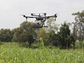
Yet, challenges loomed large due to land parcel anomalies, production underestimations, fraudulent procurement, and lack of authenticated field data. Voluntary self-reporting during crop seasons led to instances of inflated claims, causing financial loss. Satellite data emerged as a beacon of hope, aiding in cultivation verification through remote sensing technology. This initiative aimed to enhance transparency within the MSP system.
Leveraging GIS, advanced satellite imagery, and AI/ML techniques, the team collaboratively validated paddy crop at a farm level. By juxtaposing satellite data and farmers' reports, the project prevented procurement from misreported lands, safeguarding public resources. The results were remarkable – a saving of INR 1,700 crores (~ $206 million USD) and an increase in the contribution of small and medium farmers to paddy procurement from 67% to 73%.
Navigating New Horizons with Planet
Planet, with the world's largest earth observation satellite fleet, is instrumental in enhancing life on earth. In the Asia-Pacific region, Planet's impactful presence has unfolded since 2017, collaborating with governments, organizations, and partners to drive positive change. Through endeavors like these, we cultivate food security, restore ecosystems, and respond adeptly to disasters.
Stay tuned for Part Two, where we venture into New Zealand and the Philippines, uncovering how they utilize satellite data to monitor forest harvest and growth. The realm of possibilities offered by satellite data continues to shape a more resilient, sustainable future.
Discover more about these innovative initiatives and join us in harnessing the potential of satellite data for a better world.
Learn more about Planet's impact here.
Let's journey through the skies to unveil ground truths, nurture innovations, and reshape the path ahead!


