The Southwest Monsoon has officially set in over Kerala and has advanced into several parts of northeast India, marking a significant development in the region's weather pattern. This advancement brings much-needed rainfall to various states, affecting both the agricultural landscape and daily life.
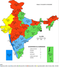
As of May 30, 2024, the Southwest Monsoon has spread across the remaining parts of the southwest Arabian Sea, parts of the west-central Arabian Sea, and most of the southeast Arabian Sea including the Lakshadweep area. In India, it has covered most parts of Kerala, Mahe, some regions of south Tamil Nadu, and the remaining parts of the Maldives and Comorin area. Additionally, the monsoon has advanced over the northeast Bay of Bengal and has enveloped most of northeast India, including Nagaland, Manipur, Mizoram, Arunachal Pradesh, and major parts of Tripura, Meghalaya, and Assam.
The Northern Limit of Monsoon (NLM) now passes through several key locations: 13°N/60°E, 12°N/65°E, 11°N/70°E, Amini, Kannur, Coimbatore, Kanyakumari, 8.5°N/80°E, 13°N/84°E, 16°N/87°E, 20°N/91°E, Agartala, Dhubri, and 27°N/89.5°E. Meteorological conditions indicate that the Southwest Monsoon is likely to advance further into central Arabian Sea, remaining parts of south Arabian Sea, Lakshadweep area, Kerala, parts of Karnataka, Tamil Nadu, the southwest and central Bay of Bengal, and the remaining parts of northeast India over the next 2-3 days. Sub-Himalayan West Bengal and Sikkim are also expected to experience monsoon conditions soon.
A cyclonic circulation over northeast Assam, coupled with strong southwesterly and southerly winds from the Bay of Bengal, is expected to bring widespread light to moderate rainfall, thunderstorms, lightning, and gusty winds (30-40 kmph) to Arunachal Pradesh, Assam, Meghalaya, Nagaland, Manipur, Mizoram, Tripura, and Sub-Himalayan West Bengal and Sikkim over the next week. Heavy to very heavy rainfall is likely in Arunachal Pradesh, Assam, Meghalaya, Sub-Himalayan West Bengal, and Sikkim over the next five days, with extremely heavy rainfall predicted in Meghalaya today.
A similar cyclonic circulation over northwest Uttar Pradesh and an associated trough extending to west Bangladesh will influence isolated to scattered light to moderate rainfall, thunderstorms, lightning, and gusty winds over Bihar, Jharkhand, Gangetic West Bengal, Odisha, and Chhattisgarh for the next five days, and over Madhya Pradesh, Vidarbha, Madhya Maharashtra, and Marathwada from June 1-3.
A shear zone along latitude 8°N over south peninsular India, combined with a cyclonic circulation over the southeast Arabian Sea off the south Kerala coast, is leading to strong westerly winds along the Kerala coast. This will result in widespread light to moderate rainfall, thunderstorms, lightning, and gusty winds (30-40 kmph) across Kerala, Mahe, Lakshadweep, Andaman & Nicobar Islands, and Karnataka over the next week. Tamil Nadu, Puducherry, Karaikal, Coastal Andhra Pradesh, and Telangana will also experience scattered rainfall.
A Western Disturbance marked by a cyclonic circulation over Jammu and a trough aloft in the lower and middle tropospheric westerlies will cause isolated to scattered light rainfall, thunderstorms, and lightning over Jammu-Kashmir-Ladakh-Gilgit-Baltistan-Muzaffarabad, Himachal Pradesh, and Uttarakhand from May 30 to June 2. Northwest India will also see isolated light rainfall, thunderstorms, and dust storms in Uttar Pradesh and Haryana-Chandigarh-Delhi.
Heatwave conditions have been prevailing over large parts of Punjab, Haryana-Chandigarh-Delhi, Uttar Pradesh, Rajasthan, Bihar, East Madhya Pradesh, and isolated areas of Odisha and Jharkhand. The highest maximum temperature recorded was 48.8°C in Rohtak, Haryana. A gradual fall in maximum temperatures by 2-4°C is expected over northwest and central India in the next five days, with no significant change expected in east India initially, followed by a gradual drop.